Archive: DEM of South Pole of Mercury
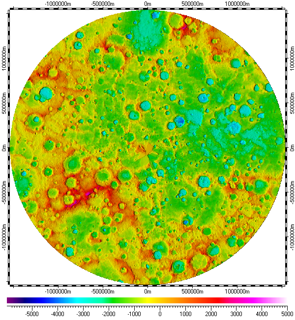
The datum of Digital Elevation Model of South Pole of Mercury, included in the archive, derived from refactored data of Mercury Double Imaging System (MDIS) DEM, version 1 of MESSENGER mission, which was prepared by USGS, and distributed by Planetary Data System (PDS) of NASA. The refactoring was based on images from Narrow Angle Camera (NAC) and Wide Angle Camera (WAC) of the MDIS. Base resolution of the datum is about 665m, but accuracy is much less than for 500m-resolution DEM of other Pole from Mercury Laser Altimeter (MLA) instrument, due principal physical constrains of the refactoring. The data uses Polar Stereographic Projection with true scale latitude of -90°.
The datum presented here generally in form of .ZRS-files (stands Zipped Raster Set), which is proprietary compressed format of author of the datum. Separated files of the datum are in hierarchical and multi-resolution relation for optimization of speed and appearance upon using in Spatial Aspect Viewer and Spatial Aspect Explorer.
Also the datum contents sparse set of spatial regions covering main features of South Pole of Mercury.
Installation prerequisites:
- Spatial Aspect Map Locator for installation process and easy launching.
- Spatial Aspect Viewer or Spatial Aspect Explorer for using.
View license agreement for using the data
Installation file:
MercurySouthPoleDISDEM.zip -
Size: 20,337,489 bytes (19.3 MB); MD5: DAABC848EAC72A577CC2557DDDB301C3.
Copyright © 2016-2023 Yuri Feldman - All Rights Reserved